Better Open Data
Cloud-native Geospatial Data for Northern Ireland
Alex Donald (Geological Survey of Northern Ireland)
Visit https://geoawd.github.io/better-open-data-foss4guk/FOSS4GUK2025.html to access the slides with videos
But first...
These formats were not around when these data were acquired
The source data is unsupported
I'm not criticising the original data - I ❤️ it
...which is why I've processed it.
Why Standards?
Open Geospatial Consortium (OGC) standards are internationally recognised specifications that let different systems exchange information seamlessly.
Interoperability
Enable seamless data exchange between different systems, platforms, and organisations, reducing integration costs and complexity.
Data Consistency and Quality
Promote uniform data formats, definitions, and structures, leading to higher data reliability and easier validation.
Efficiency and Cost Savings
Reduce duplication of effort in data collection, processing, and analysis by allowing reuse of tools and datasets.
Scalability and Future-Proofing
Support scalable solutions that can grow and adapt with evolving technologies and datasets.
Compliance and Collaboration
Facilitate compliance with national/international regulations and foster collaboration across sectors and borders.
Avoid Vendor Lock-in
Not tied to any particular software, storage, or delivery platforms.
Cloud Optimized Geotiff
Performance
COG's are designed for efficient access, allowing for quick retrieval of data without loading the entire file.
Compatibility
COG's are widely supported by GIS software, cloud platforms, and web mapping libraries, ensuring interoperability.
Reduced Duplication of Data
Store your primary data as single file that can be served online instead of needing to process, copy and cache the data.
Scalability
COG's can handle large datasets efficiently, making them suitable for big data applications in geospatial analysis.
How do COGs work?
File structure + http technologies
File Structure
COG's are a specific type of GeoTIFF, optimised for cloud storage and access.
HTTP Range Requests
HTTP Range Requests allow clients to request specific parts of a file, enabling efficient data retrieval without downloading the entire file.
COGs are structured to support these range requests, allowing for efficient access to specific tiles or bands within the raster data.
You're probably all using http range requests (thanks streaming video!)
and most of you have probably accessed COGS thanks to Planet.
COG Compression
Lossy and lossless compression options available
TL;DR: compression, in the case of these LiDAR data, can make the data 1/3 of the size with no loss of resolution.
View the speaker notes for details of methods and their suitability.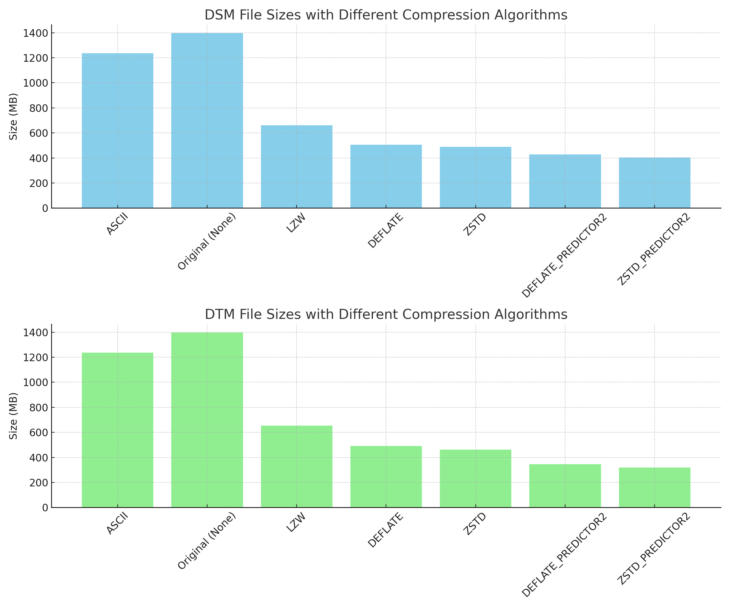
How do I make a COG?
from osgeo import gdal

input = r'input.vrt'
output = r'output_file.tif'

translate_options = gdal.TranslateOptions(format='COG',
		creationOptions=["COMPRESS=ZSTD",
						"BIGTIFF=YES",
						"PREDICTOR=2",
						"IGNORE_OVERVIEWS=YES",
						"NUM_THREADS=ALL_CPUS"],
						outputSRS='EPSG:29902')
gdal.Translate(output, input, options=translate_options)
import os
from osgeo import gdal

input_dir = r'lidar-source/'
output_dir = r'lidar-cog/'

for f in os.listdir(input_dir):
    if f.endswith('.tif'):
        input_file = os.path.join(input_dir, f)
        output_file = os.path.join(output_dir, f)

        translate_options = gdal.TranslateOptions(
            format='COG',
            creationOptions=[
				"COMPRESS=ZSTD",
				"PREDICTOR=2",
				"IGNORE_OVERVIEWS=YES",
				"BIGTIFF=YES",
				"NUM_THREADS=ALL_CPUS",
				"STATISTICS=Yes"],
            outputSRS='EPSG:29902'
        )

        gdal.Translate(output_file,
					   input_file,
					   options=translate_options)
better-open-data.com*
An experiment with COGs that might be useful...
*I needed a domain and couldn't think of anything...- Source Lidar data (OpenData NI)
- Process data (Python) - custom COG Converter
- Analysis (view results) and standardised the units with gdal_calc.py
- Display data - Build an Open Layers web map
- Create a STAC
Open Layers and Geotiff.js
Custom hillshade function to display the raw pixel data as an interactive hillshadeDEMO TIME
Let's hope the internet is working!
If you aren't at the FOSS4GUK 2025 conference, there are a series of videos on the following pages that you can view.
Where's the site/data...
- Raspberry Pi (self hosted as better-open-data.com) Storage and bandwidth is not an issue!
- Also hosted on GitHub Pages (I've yet to see a GitHub page break!)
Where should the data be...
- Amazon S3
- Cloudflare R2
- Google Cloud Storage
- Microsoft Azure Blob Storage
- Digital Ocean Spaces
- MinIO (self hosted)
Not just geospatial data...
In summary
COGs are really good geospatial storage *and* delivery format
If you have open LiDAR data get in touch...
All the code is on GitHub
Thanks!
awdo@bgs.ac.uk
Useful links
cogeo.orgGDAL - COG Driver
Rasterio
STAC in QGIS